


What is GPS and how does it work?
The Global Positioning System (GPS) is an electronic system that uses satellites, cellular technology, a receiver, and algorithms to show the position on Earth of a asset such as a car, boat, RV, mobility scooter, or a person.
GPS simplified

Illustration of satellites and The Earth
What roles do satellites play?
GPS relies on satellites – at least 24 of them – that circle the Earth. The system is owned by the U.S. Department of Defense. The Department originally put the satellites into orbit for military use, but they were made available for civilian use in the 1980s.
There is also a system of GPS satellites operated by the Russian Federation called GLONASS.
Satellites transmit signals that GPS trackers decode to calculate the device’s exact location.
But satellites and GPS devices need a network of ground stations to monitor the positions of the satellites constantly, in real-time. The accuracy of GPS data depends on knowing the exact positions of the satellites at all times.
These stations monitor the GPS satellites, checking both their operational health and their exact position in space. The master ground station transmits corrections for each satellite's position and clock offsets back to the satellites themselves.
Since GPS satellites travel at relatively high speed around the Earth, they need very accurate clocks. Einstein tells us that a clock heading at high speed toward/away from us will have a different clock speed relative to a static clock on Earth. This can actually be measured. There is a small offset in the GPS receiver to account for satellite motion.
The satellites can then incorporate these updates in the signals they send to GPS tracking devices.
There are monitoring stations in Hawaii, Ascension Island, Diego Garcia, Kwajalein, and Colorado Springs among other locations.
Radio technology is still key
What’s a radio receiver? Also known as a radio, a radio receiver is a device that receives radio waves and turns them into a usable form.
Radio receivers are at work in baby monitors. They help parents keep an eye on their baby in their crib while the parents are in other parts of the house. The monitor hears what the baby is up to and transmits those sounds through radio waves to another radio receiver for the parents to hear.
Another form of radio receiver is a device we are all familiar with – a cellphone. It’s connected to a telephone network by radio signals exchanged with a local antenna called a cell tower.
Cellphones usually also have several other receivers that connect them with other networks: a WiFi modem; a Bluetooth modem; and a GPS receiver. Cell towers have sophisticated multichannel receivers that can receive signals from many cell phones simultaneously.
What are algorithms and what do they do for GPS?
Algorithms are a series of well-defined instructions that tell a device how to solve a set of problems – calculations, data processing, reasoning, and decision-making for the GPS.
Think of algorithms as the brains of the GPS. They tell the GPS what to do. Of course, there’s nothing magical about this. Algorithms may be the brains of the GPS, however human beings prime the algorithms, telling them how to process data – for example, your car’s position, relative to where nearby restaurants are and what is the best route to the closest one.

Image of car on highway
How accurate is GPS tracking?
When it comes to tracking, that is, following the course or trail of someone or a vehicle or some other valuable asset to find them or note their location at various points, a real-time GPS tracker is remarkably accurate.
Your real-time or live tracking device can communicate with at least four different satellites at a given time and use this communication to get your current location information (eg. latitude, longitude, altitude, speed, route, etc.).
These satellites transmit signals to one another, and the GPS device can measure these transmissions to calculate the precise location of your tracking device.
Weather conditions don’t interfere. But skyscrapers, mountains or other obstructions may interfere. Or if you’re searching in a parking garage, there may be a problem. But in the end, in general, the reading will be accurate within three meters (9 ft.)
What is data? What is information? And the difference between the 2
Data are plain facts, such as: longitude, latitude, altitude, time, speed, etc.
When these facts are organized to make them useful, they are called Information.
One piece of data is a bit. Eight bits make a byte. A kilobyte is 1,024 bytes. 1,024 kilobytes make a megabyte. And so on.
Your computer, laptop, tablet, and cellphone store data and turn it into useful information at your fingertips. In the case of a real-time GPS system, the GPS data is collected by the tracker, from the satellite and cellular network, and decoded by and app, like WhereSafe’s, so users can easily see real-time asset location.
Real-time GPS versus Location By Request or SMS
Real-time GPS tracking systems use cellular wireless or satellite communication to give users real-time data on, for example, the current location of a loved one, or vehicle.
Real-time GPS is based on the regular interval ping rate - e.g. every two minutes - where the GPS receiver pings the network. Real-time GPS provides an instant view of the actual current location of a GPS tracker, and therefore can also instantly notify users when events occur.
This is unlike location by request which requires users to “ask” for GPS location data when they need it. One downside here is that, if you do not request location at the right time, you may miss something critical. For example, if you request the location of a truck three days after it was stolen, you will likely be too late to recover it.
SMS (short message service) is a text messaging service component of most telephone, Internet, and mobile device systems. SMS is often used for location by request GPS services as a command service to trigger a GPS tracker for location data, over the air.

Diagram shows how WhereSafe GPS signals are processed, then notifications are sent to the customers device.
The weakness of SMS is that message delivery is not guaranteed, and there’s no way a sender can determine whether an SMS message has been delivered in a timely manner.
SMS messages are generally treated as lower-priority traffic; others may not be delivered until long after they are needed. Whereas GPS data is automatic and sent via 3G, 4G, 5G or Cat-M IOT networks (we will explain these in another blog article).
On Board Diagnostics
Every car built after 1996 is equipped with an onboard diagnostic (OBD-II) port. Ever since 1996, most vehicles have computer systems that keep an eye on their cars emission control systems and more.
Now OBDs are at work in most vehicles, monitoring and regulating their performance. OBDs keep an eye on the performance of major engine components, watching for failures that might cause excess emissions, engine damage or other inefficiencies.
They also watch the fuel injection system, which controls the fuel flow into the engine. When the engine needs less fuel, the onboard computer directs it to gets less.
OBDs gather information from a network of sensors inside the vehicle. The OBD monitors the car’s oil levels, alignment, tire pressure and so on. Using an OBD reader the technician will quickly know what needs fixing. All the technician needs to do is plug into the OBD system to see what’s working and what’s not.
The next time you take your car in for a checkup, the service advisor may present you with what looks like a set of X-rays of what’s going on under your car’s hood and what the OBD says needs fixing. It’s not your service advisor’s opinion. It’s the OBD’s inside look at what needs attention.
OBDs also warn car owners when something needs fixing.
OBDs send messages to the dashboard. The check engine light is a signal from the car's engine computer that something is wrong – could be a loose gas cap or something more serious. Should the light begin flashing, however, it indicates a more serious problem, such as a misfire that can quickly overheat the catalytic converter.
Many popular GPS tracking devices plug directly into the OBD-II port. These OBD GPS trackers are extremely easy to install, as the port can be easily found just under the steering wheel in most vehicles. OBD trackers allow for more detailed data about the vehicle to be shared with the backend GPS software.

We often use these words when we talk about GPS tracking devices and other devices. But did you ever wonder what they mean?
Hardwired – aka wired - is a device that is physically built into the computer (or vehicle) instead of programmed into the software. It can’t be easily removed. There are physical wires connecting the GPS modem to the asset, for power and/or data transfer.
Often used to track cars, trucks, ATVs, motorcycles, snowmobiles and more, hard-wired GPS trackers such as WhereSafe’s Sport Tracker is easily installed by a technician and can be hidden away to prevent tampering. A hard-wired Sport Tracker is wired directly into the vehicle or power, ignition and ground.
Portable magnetic GPS devices – These magnetic trackers need not be wired into the asset to track it. These devices, like WhereSafe’s MagTracker; Mini GPS Tracker; and XTracker (extended battery) are water- resistant and can be mounted on any magnetic surface of the asset. These are popular for owners of RVs, vehicles boats, trailers, mobility devices and more They are portable, so can be moved between assets (re. from you truck to you boat) and can also be mounted in various manners (eg. adhesive mounting plates for non-magnetic surfaces) or hidden in a glove box.
Bluetooth is a short-range, wireless signal that is used for exchanging data between fixed and mobile devices. The range of the connection is approximately 10 meters/30 ft. However, maximum communication range varies, depending on obstacles such as a wall.
Bluetooth is used in tracking for BLE (Bluetooth Low Energy) tracking. BLE is a radio frequency (RF) technology used for short range, often indoor, tracking of people and assets. BLE can be tied into and supplement GPS tracking apps, such as WhereSafe, for those who require alternate tracking options.
Two-way communication and GPS
Two-way communication is a form of transmission in which both parties involved transmit information. Examples are chatrooms and instant messaging. But chat rooms and the like have gone the way of the landline, replaced by Zoom, FaceTime and social media.
GPS trackers also offer two-way communication, whereby the tracker relays data communications back to the cloud based web service and application. Some GPS modems offer one-way SOS communications for emergencies. The devices largely can be communicated with remotely, over the air by administrators to send new programming scripts.
What are data inputs?
Any information that is fed into a computer or a software program is known as input.
Since the information provided is also considered to be data, the process of providing information to a computer is also known as data input.
Data inputs instruct the computer to do what it is designed to do: produce an output. So, the word or phrase you type into the text box of your search engine is the input which it will process and produce an output for you.
Devices such as the keyboard on your computer, mouse, scanner, and a digital camera are input devices. Sensing hardware monitor data inputs and communicating those though a given communications radio, Bluetooth, cellular or GPS network, is known as telematics and the internet of things (IOT).
A practical example of an input in the telematics world of GPS is a siren going off. With the right GPS modem, and application like Trackem GPS can take that event and output that into the reporting/dashboard on the app for monitoring, warning and/or reporting purposes.
Another example of an input is a vehicle leaving a certain pre-defined area or Geofence.
What is a Geofence?
A geofence is a virtual geographic boundary, created by a user and defined by GPS technology, that enables software to trigger a response when a GPS tracker enters or leaves that boundary.
The result is a response or output from the reporting/dashboard of the WhereSafe or Trackem GPS app. For example, geofence entries/exits can trigger email, SMS or push notifications to users of the system, emergency contacts, parents, managers, etc.
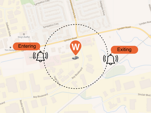
Diagram showing Geofence
GPS goes to work doing fleet tracking
It’s 8 pm. Do you know where your fleet is?
A vehicle tracking system (VTS) or fleet telematics system (FTS) uses GPS to locate the vehicles in a fleet and uses software that collects fleet data to advise the fleet manager, vehicle dispatching office or small business owner about how its vehicles are operating and performing.
Individual vehicle and/or fleet information can be viewed on digital maps by way of the Internet or specialized software and mobile applications (apps).
A VTS can collect data on driving behaviour, fuel use, mileage travelled, stops, ignition on/off, geofence entries/exits, (and so much more). for each vehicle in the fleet. It can locate the vehicle on a live map 24/7. It can keep track of maintenance – what’s been done and what needs to be done to make sure each vehicle gets needed maintenance on time to meet warranty demands or just best practices preventative maintenance.

Illustration of delivery vans being tracked on map
A VTS can keep track of each vehicle’s speed, route and stops throughout the day: when the vehicle started out and when it arrived to find out the best routes and best times of day for delivery.
When vehicles are outfitted with GPS modems that feature 3-axis accelerometers, the GPS/telematics system can allow fleet managers to monitor driver behaviour to keep an eye on speeding, harsh turning, aggressive breaking, collisions, U turns and long stops. This can be used to provide feedback/education to drives to correct poor driving behaviour. Obviously this could be a valuable tool for businesses, and one can easily see how mom and dad could benefit too from access to these data inputs.
Trailer and Container Tracking
Fit a GPS tracker to a trailer or container and you have trailer tracking.
Knowing the real-time location of cargo in transit can help with dispatch and customer service.
Besides location tracking for logistics, theft and efficiencies, a container tracker can be used to send instant notifications for door open and close. Trailer theft is unfortunately becoming more common. So, GPS is vital to protecting the trailer and the cargo. Knowing exact real-time location of stolen property will give law enforcement a great advantage for successful recovery. Using magnetic trackers, provide the option to track either the trailer itself, or the valuable cargo or both, with multiple trackers in place.
These trackers connect trailer owners to a variety of popular trailer types such as enclosed trailers, open car trailers, equipment trailers, utility trailers, dump trailers, fifth wheels, toy haulers, open gooseneck trailers, livestock trailers, refrigerated trailers and step deck trailers.
The simple to use mobile app is designed to provide a precise real-time location of a trailer and provide access for multiple users to monitor the asset. Customizable and automated instant notifications via text message or email can be set up for tamper alerts, movement alerts, and geofence alerts on entries and exits to specific locations.
Personal uses of GPS tracking devices
A mobile app is a computer program designed to run on a cell phone, tablet or a watch. Of course, you download them from the App Store or Google Play app on your cell phone, tablet or watch.
Mobile apps have become part of our daily life. We can check our email without using a desktop computer, buy a plane ticket, do our banking, play games, check the weather, see the location of our GPS equipped assets, and so much more, hence the saying, ‘there’s an app for that.’
Family Safety and GPS
GPS to Monitor Teen Drivers
Getting behind the wheel can be an exciting time for teens but an unsettling time for their parents.
Parents can install GPS trackers and download an app, such as WhereSafe, to monitor their teen while they are behind the wheel. These apps let parents set limits and monitor driving habits, including sudden acceleration, speeding, geographic boundaries and more. Alerts for breaching any set limits can be set, to notify the parent by SMS and/or email when a teen driver is doing what they are not supposed to.
Subsequently, the account can be set whereby the teen driver also receives the same over speed notification. The theory is, that if they get a notification and know mom or dad did too, they will correct their behaviour and ease up on the accelerator.

Image of teen learning to drive
Parents may want to be alerted when their teen has left a given location or the city limits. Geofences can be set so parents know when kids arrive at, or leave predefined places. In times of emergency, GPS can tell an anxious parent where their teen driver is and get them help if needed.
Think of it as a fleet tracking app simplified for teen drivers.
Eldercare apps
Your parents cared for you and now it’s your turn to care for them. These apps let you keep an eye on an elderly parent remotely. They won’t replace caregivers, but they do help make caregivers’ work easier, especially when the senior is handicapped or suffers from dementia or Alzheimer’s.
Real-time GPS tracking such as the WhereSafe’s GPS trackers allow these seniors more freedom and lets their loved ones and caregivers breathe easy, knowing the are not lost and actively moving.

Image of a man out for a drive on a mobility scooter.
The system is designed to provide precise live location of a loved one, to a cellphone app for multiple users. Geofences can be set to surround a house, block or care facility property. Instant notifications via text message or email can be set for family members or caregivers when the person or mobility device moves, or if it has left a predefined location, like a house or care facility.
WhereSafe trackers can be locked, magnetically attached or place under the seat of a mobility scooter or walker. They can also be placed in a purse or bag.
Keeping an eye on senior drivers.
Your parents also kept an eye on your driving habits when you were a teen, and now you may be concerned about an elderly parent on the road. Those driving apps you used to make driving safe for your kids can do the very same for seniors, who may have diminished memory, eye sight or driving skills in general.
The WhereSafe smartphone app keeps in constant contact with your tracker to provide access and updates at a glance or by push or email notifications, if a set parameter has been violated eg. speed, geofence, or night driving.
An OBDII tracker is plug and play, and activated once the app is installed on your smartphone. The app was built to allow users to put down their phone, eliminating manual check-ins, so WhereSafe can do its job and notify you if you need to know.
A simple to use GPS tracking app can tell a relative or caregiver or multiple users, where the senior driver is and get them help if needed.
Theft protection for your car and other high valued assets
You may not be able to keep a thief from getting their hands on your car, boat, ATV or landscaping trailer, but you can instantly find out where that asset is with a GPS tracker and corresponding mobile phone app.
They are easy to install. Just plug the real-time tracker into your car’s OBD-II port, cigarette lighter, hardwire it into the ignition or get trackers that are wireless and magnetic to simply stick onto an asset or place in a glovebox. If a theft happens, you can simply provide law enforcement app account access to find its location for easier recovery.
GPS trackers can be fitted to keep track of your motorcycle, RV or travel trailer, lawn tractors, jet skis, your mom or dad’s wheelchair or scooter, business equipment, shipping containers and more.
In fact, settings in systems like the WhereSafe GPS app, allow for instant text or email notifications if the asset moves at night or other predefined times when it is not supposed to, or if it has exited a geofence, or if you wish, any time it moves.
Here’s what’s going on when a GPS tracker is at work
GPS tracking systems began as a strategic military tool that became adopted by businesses. After some time and familiarity, and the fact that civilians are being tracked today in so many ways, GPS has become more comfortable for everyday people. Consumers now see the value in the technology and are less likely to view it as an invasion of privacy or ‘big brother’.
GPS helps us stay connected to our valuables and our loved ones 24 hours a day, 365 days a year.
The future for GPS systems, telematics and IOT is a bright one. The industry size was estimated at $38 billion in 2017 and expected to grow to $146 billion by 2025 (according to Grandview Research). The technology is becoming more accurate and adaptable to a wide variety of uses daily. Limits depend only on our needs, imagination and creativity. So, there is much more to come and WhereSafe will be there to “Protect your Passions” while Trackem GPS continues to help businesses stay connected to their operations and employees.

Image of cars